:::
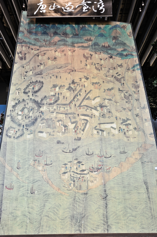
Map of Taiwan under the Reign of Kangxi (partial)depicting area of Taiwan prefectural city


This map of Taiwan was made during the Kangxi Period in the Qing Dynasty, and it shows the partial enlargement of Tainan and Taijiang Inland Sea area. The map also depicts details of the landscape, culture and customs of Tainan during the early Kangxi Period of the Qing Dynasty. At the time, the Qing Government set Luermen as the only legal point of entry and exit between Xiamen, Fujian and Taiwan.
After crossing the Taiwan Strait and arriving safely in Luermen, Anping, since the watercourse in Taijiang Inland Sea was very shallow and unable to be navigated by large, oceangoing ships, people and cargo were then transferred to smaller sampans and transported to the dock outside the west gate of Tainan. For even shallower waters unreachable by the small boats, oxcarts or dock workers would come and take the cargo and passengers to shore, as the picture vividly shows.
:::
- 地址:709025臺南市安南區長和路一段250號
- 電話:06-356-8889
- 傳真:06-356-4981
- 無障礙服務專線電話:06-356-8889 分機 8103
- 更新日期:2025-03-24
- 訪客人數:1,592,401
國立臺灣歷史博物館著作權所有 © National Museum of Taiwan History. All Rights reserved.